To identify, and demonstrate, approaches that can be taken to:
The key research questions to answer are:

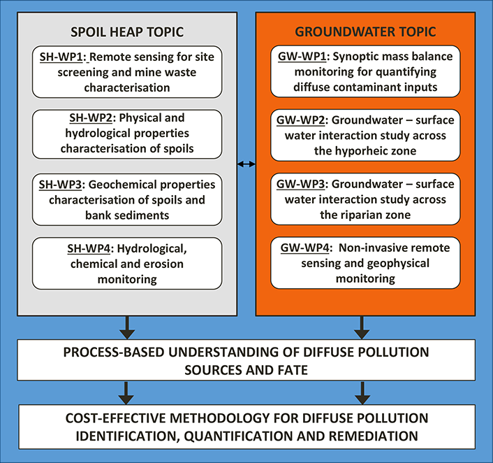
Figure 1 - DIFFUSE project structure
Figure 1 presents the project structure showing the work packages and key objectives. The two research areas themes "Spoil Heap topic" and "Groundwater topic" and their activities are closely aligned.
Our approach to monitoring entails the coordinated use of a range of different techniques, so that together the data generated will provide insights into (1) the provenance, nature and scale of spoil-heap derived pollution sources and (2) the role of stream – groundwater exchange processes across varying hydrological conditions in governing metal load in surface waters.
In the Spoil Heap topic non-invasive techniques such as visible and hyperspectral scanning using Unmanned Aerial Vehicles (UAVs) will be employed to survey catchments and identify key properties of spoil relating to the potential for erosion and leaching, such as volume, distance to watercourse, evidence for physical erosion (e.g. rills) (WP1). Detailed physical and chemical characterisation of spoil and bankside soils (WP2, WP3), coupled with the installation of equipment for monitoring the hydrological properties and chemical behaviour of spoil, bankside soil and surface waters, will lead into monitoring (WP4), which will combine regular and event-based activities in order to provide comprehensive data on the pathways and mechanisms of metal transfer from spoil to bankside soils and surface waters under varying conditions of precipitation amount and rate. This will allow us to assess the contributions of spoil areas to surface water metal loads, to quantify the relative contributions of infiltration and erosion to such loads, and to assess the underlying mechanisms controlling the magnitude of loadings under varying hydrology.
In the Groundwater topic, we will use synoptic sampling (WP1) of surface water chemistry and flow for quantifying diffuse inputs and their spatial distribution; we will be able to focus on identified metal gaining / losing reaches in WPs 2 - 4. At these diffuse input sites we will install networks of multilevel samplers and nested piezometers across two functional units, the “hyporheic” (WP2) and “riparian” (WP3) zones, for quantifying groundwater-surface water exchange and metal uptake/source to the stream, aided by tracer injection experiments at reach level from WP1. Besides providing evidence (data) and understanding of the importance of this zone to the instream metal load, we will employ non-invasive monitoring techniques (WP4) such as geophysical electrical tomography to address the inherent spatial heterogeneity of the hyporheic zone by producing 2D to 3D profiles, and to monitor dynamic processes (e.g during solute injection); we will also explore the applicability of infrared thermal imaging (via drones and instream sensors) to detect thermal gradients associated with deep mine water inflows.